Recently, the idea of the “15-minute city” or “20-minute city” — an aspirational vision of the city in which most of the needs of its inhabitants can be met within a 15 or 20-minute walk, cycle or public transport trip from any location — has captured the imagination of planners and policymakers around the world, from Paris to Melbourne, and beyond.
Inevitably, cities around the world are defining those needs by their own criteria. Portland, in the US, has defined the four most key pieces of infrastructure to a 20-minute city as public primary schools, grocery stores, green stops and public transport stops with minimum travel frequency standards. For cities with more elderly populations, access to health may also be considered an essential factor in creating a 15 or 20-minute city.
Regardless of the metric or methodology, Podaris makes it easy for planners to understand how their city measures up. In this blog post, we'll walk you through the process, introducing some powerful new geospatial analysis features along the way.
Using travel time tools in Podaris
Our powerful geospatial analysis capabilities have long made it easy to understand accessibility and connectivity. With one-click travel time isochrones, it is possible to not only visualise multi-modal access across the street network or a transit network but also rapidly surface insights from demographic datasets.
In the following example, we're going to explore travel times to hospitals within Leeds, England. By connecting census data, we can understand how many people with long term health conditions are able to travel to these hospitals within 30 minutes by walking. We can then see how these people are currently served by existing transport infrastructure in the area.
You can also view a more complete video tutorial of this process.
Unlike traditional processes, doing this in Podaris takes minutes rather than hours!
Recently we added a powerful new capability to our isochrone tool: the ability to set the starting location of your travel time isochrone as either a single point, or multiple points determined by a query.
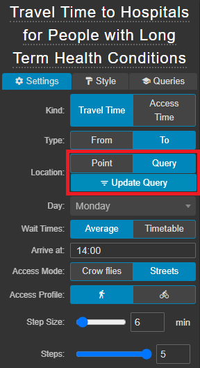
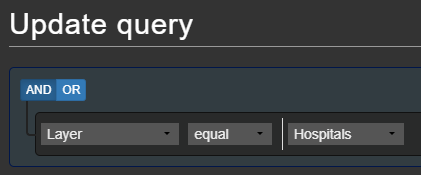
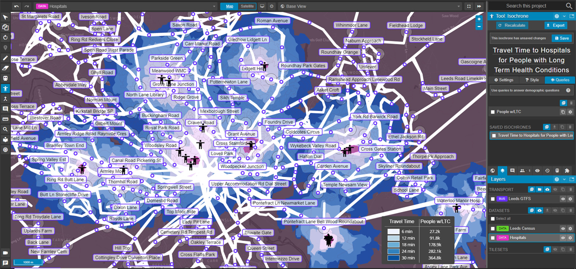
We're going to update this location query to target entities on a dataset layer titled ‘Hospitals’, which has locations for all hospital facilities in the region.
With our access profile set to ‘walking’ we can already see the areas reachable by a 30 minute walk to or from our hospitals.
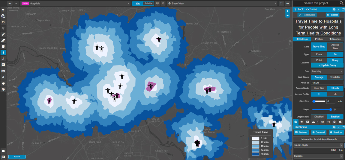
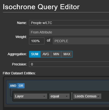
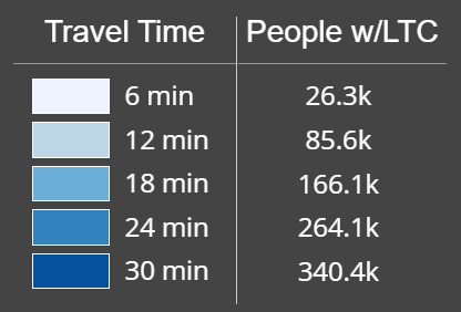
To help us understand what this means in terms of the hospital's reachability by people living in the area (in particular, those with at least one long-term health condition), we can import census data as a new dataset, and create a query that sums the number of such people in the area.
In minutes, we've been able to answer the question of how many people with long-term health conditions can walk to a hospital in Leeds in 30 minutes or less.
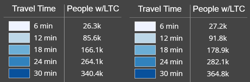
Let's take it further, and see what effect adding existing public transport options in the area has on travel time. Importing a GTFS feed is as simple and instantaneous as importing datasets in Podaris - once the import is complete, we can immediately recalculate our query in a single click, with the new transport layer informing our outputs.
Below, we can clearly from the new outputs on the right, that adding the transport network enables approximately 24,400 more people to make a journey to a hospital in 30 minutes.
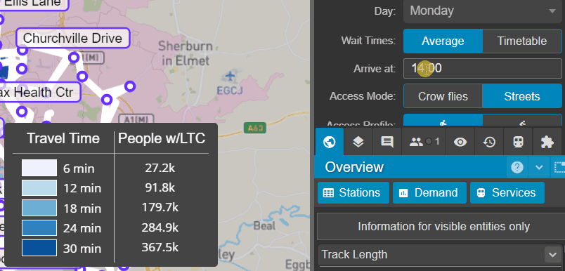
The outputs that we're seeing here are in the context of our public transport routes running at a particular time and day. Podaris allows you to inspect the outputs of any date and time easily by making quick changes through the isochrone tool.
With these new querying capabilities, Podaris enables sophisticated demographic analysis more simply and quicker than ever before. All of these features are available as part of our low-cost subscription-based enterprise licenses. To discover how Podaris can help solve your transportation needs, get in touch today to schedule a demo with a member of our team.