Out With The Whip, In With The LCWIP
Since the beginning of the pandemic, traditional transport services have been radically altered in response to plummeting ridership and farebox revenue, staff shortages, and the ongoing need to provide services for key workers and transport-dependent populations. Local authorities, municipalities, and agencies from cities and towns across the world are needing to respond to changes in travel needs and behaviours faster than ever.
Globally, one thing is clear: the most innovative responses have been in the form of changes to the public realm. Streets have been pedestrianised, pavements have been widened, and temporary cycle lanes added. Not only has there been immense pressure to deliver these interventions quickly, but for the most part, they have been planned by entirely remote teams consulting stakeholders and citizens digitally.
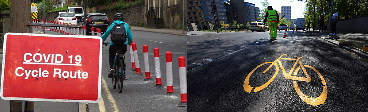
In the UK, cycling volumes have been increasing week on week. Although hourly road-traffic volumes have almost returned to pre-lockdown levels, many are hopeful there is still a modal-shift revolution to be had, one of which is none other than British Prime Minister Boris Johnson who vowed to bring about a “golden age of cycling”. With this week’s announcement of an additional £2 billion being made available for cycling and walking, there is now more need than ever for rapid remote planning. So how can Podaris help?
Podaris is the world’s only online platform for real-time collaborative multi-modal transport planning, engineering, and stakeholder engagement. It is available for a low-cost subscription to anyone from local authorities to consultancies anywhere in the world. The platform is used to plan, analyse, and communicate transportation interventions of all sizes - from temporary cycle lanes to bus or metro reconfigurations. Now, more than ever, planners need to make use of cloud-based solutions for better online collaboration and stakeholder engagement.
The pandemic has necessitated rapid interventions in the provision of transport services and the street space to enhance social distancing. When these interventions are poorly designed or badly implemented they can have significant adverse impacts, and can erode trust with key stakeholders and citizens as a whole. For instance, the poor pop-up cycle lane in Manchester, that was “popped-down” within 12 hours.
12 hours later, the cycle lane is gone... pic.twitter.com/KRy1NRLcqo
— WalkRideAlty (@WalkRideAlty) June 23, 2020
Podaris is an easy-to-use platform which helps you plan rapid interventions in public transport services and allocation of street space, with better collaboration between organisations, more accurate understanding of the costs and benefits of the interventions, and more transparent communication with affected stakeholders.
How does Podaris help with planning Cycle Infrastructure?
While there are many examples of poorly designed or communicated interventions, there are also many great ones. Birmingham City Council is an example of an authority that has responded rapidly, democratically, and holistically, launching a number of pop-up cycle lanes, pedestrian streets, and low-traffic neighbourhoods as a response. Below are some ways that Podaris can help.
Parametric design
Napkin sketching is usually the first point of call for any plan. These hand-drawn napkin sketches are fast to create, but hard to iterate and share with collaborators. Further, they are often highly schematic, relying on intuition, experience, and high-level assumptions to develop, making them inaccessible to non-technical stakeholders like councillors or the public. Traditionally these have been necessary because there is no time or budget to do detailed engineering, especially during the early stages of project planning, when many different scenarios need to be rapidly evaluated. These simplifications, however, can become quite problematic. Too often, seemingly small details of the site or the engineering turn into significant difficulties later.
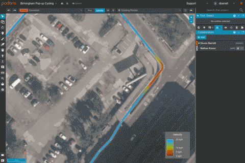
Podaris solves this problem with advanced parametric modelling tools. These tools are intuitive enough for planners to use, but also well-grounded in the engineering parameters of the systems they represent. In this way, planners can draw simple lines on a map, and the resulting right-of-way footprints, turning radii, travel times, and so forth are calculated dynamically, providing far more accurate than anything that could be achieved via simple rules of thumb - enabling planners to experiment more freely, without fear of violating engineering constraints.
For cycling infrastructure, this allows you to quickly identify junctions which could be widened to provide smoother throughflow via easy to visualise velocity profiles that accurately calculate the velocity, acceleration, and jerk tolerances of the paths you draw.
Do all of this collaboratively
Working remotely certainly comes with perks - no more commuting or ironing! However, for many transport planners, this has completely changed existing processes. No longer can designs be collaboratively discussed and sketched on physical maps around a table, nor can citizens be consulted through town hall meetings. Some planners have found refuge in generalised cloud-collaboration tools like Miro or Google Docs - which, while collaborative, are not well-suited to geospatial transport planning.
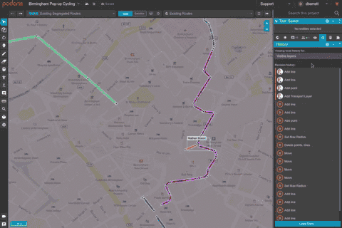
Podaris brings these kinds of cloud-collaboration capabilities to the world of transport infrastructure planning. Planners can create accurate transport plans collaboratively in real-time, using advanced revision controls, to do so safely, understanding who made each change, which layers were affected, and where on the map the change occurred.
Get quick answers to critical questions
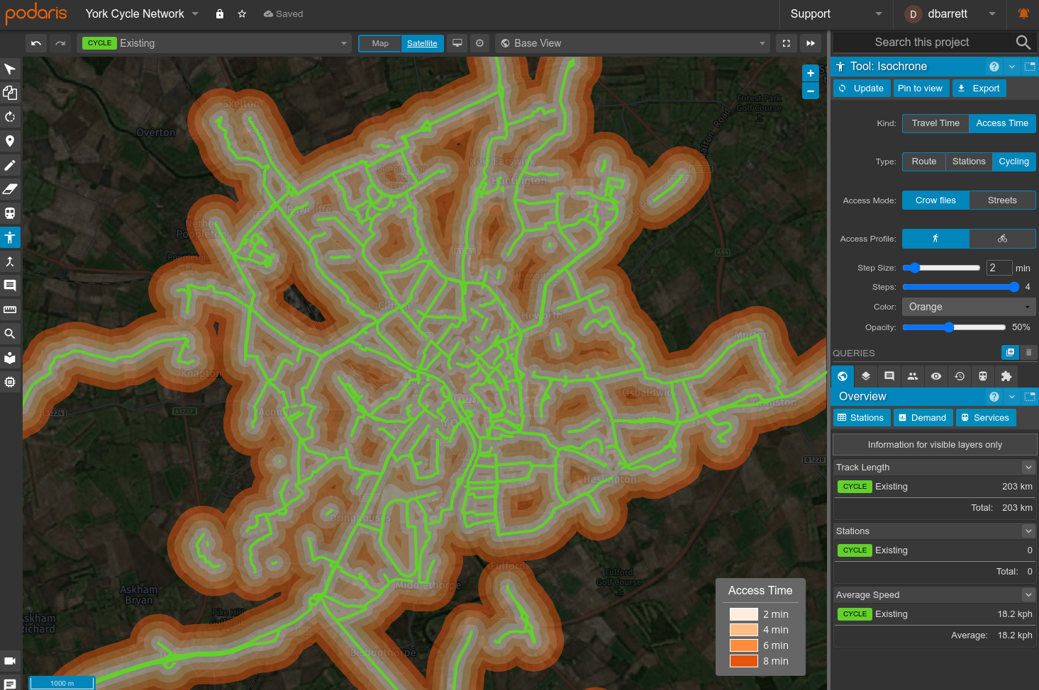
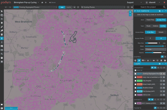
Following the napkin sketch phase, you are often left with many options. How do you decide which ones are worth building? Podaris makes it easy to harness the combined power of any dataset to quickly perform advanced demographic analysis, understanding the real-world impact of proposals in a way that matters to your local environment. In the context of cycling interventions, this could mean answering the following sort of questions:
- How many people live within a 10 min cycle of the proposed route?
- Are the proposed route options integrated with existing cycle parking facilities?
- Which route option has the highest average propensity to cycle?
- Does route A or B provide access to more job sites?
These questions and more take minutes to answer within Podaris. Below we show how easy it is to quantify the number of people that have access to a dedicated cycle lane (as per the 2011 UK census LSOA data) with and without the proposed pop-up cycle lanes within Birmingham.
Appraise and build a business case
Appraising and analysing the identified cycle routes can be done in many ways, from costing to quantifying CO2 reductions. Podaris is a cloud-based platform which makes it easy to utilise external tools and plugins to calculate arbitrary KPIs within tools you are familiar with. Integrations with various spreadsheet applications provide a way to synchronise key metrics and attributes from your Podaris projects in realtime. Helping to ensure any derived calculations are always current, and reducing the need to ask colleagues for the latest version.
Below we demonstrate how the Podaris for Google Sheets integration could be used to create an interactive cost model.
First, we start by connecting the Podaris project to a spreadsheet using the Google Sheets plugin. Once done, statistics from the project will begin synchronising in real-time. These statistics can include travel times, track length, demographic analysis results, and for transport networks, fleet requirements and timetables. With these statistics, any type of derived calculations can be created by referencing the current data within the spreadsheet.
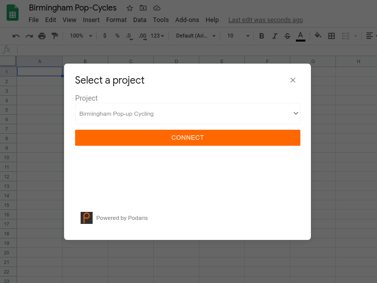
In addition to synchronising data from Podaris, through the plugin, you are also able to send data to Podaris - perhaps to report costs for scenarios or illustrate core KPIs to stakeholders through Podaris:Engage. These values will then be automatically sent to your Podaris project whenever they change, providing a live connection to data, enabling opportunities for bi-directional headless real-time workflows. For example, in Birmingham, when a planner modifies a cycle route, the changed statistics are then sent to the spreadsheet, which immediately updates the calculated route-cost (since that referenced the live data). Finally in-turn the cost is sent back to Podaris, allowing the planner to see the impact of their change.
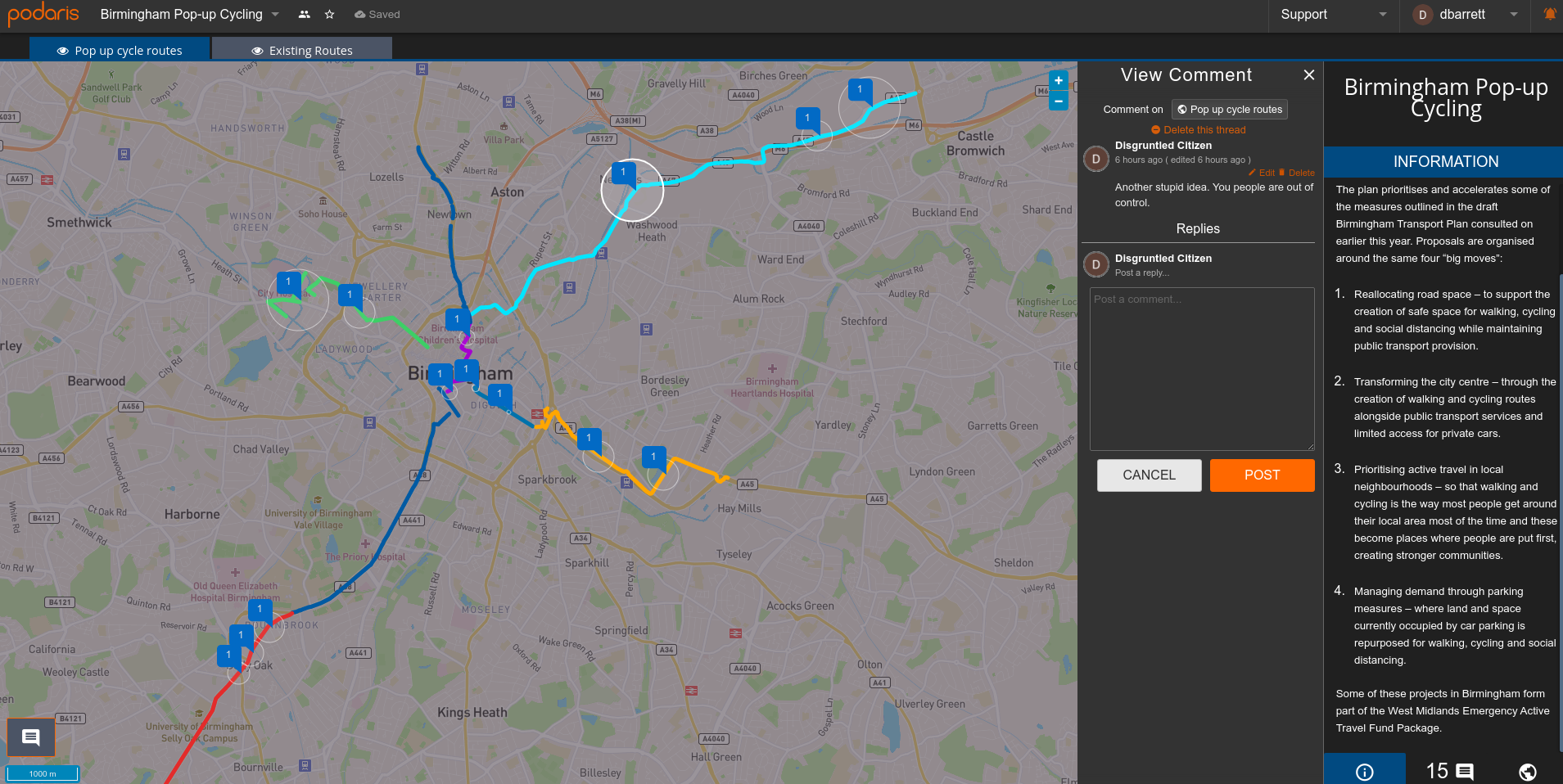
Engage stakeholders
Traditional public consultation processes are either ineffective or unavailable in the pandemic. Notices posted to lamp-posts are universally ignored, while with letters with long notice periods and in-person town hall-style engagements are currently not possible. Some planners have turned towards digital ways of engagement through powerful tools like Commonplace (which can be used to present the plans you create within Podaris), other organisations have consulted with stakeholders less than they usually would. Whilst these interventions need to be made quickly, by not engaging with stakeholders early and interactively, you risk eroding trust and not gaining the buy-in required for these to be successful.
Podaris offers a digital light-weight stakeholder engagement tool as part of the core platform. It is allowing you to open a collaborative dialogue with your chosen stakeholders - from citizens to local cycling advocacy groups, even councillors. Podaris:Engage provides a presentational window into the different cycling proposals and scenarios as a means to engage stakeholders in conversation through pinned comments. This offers a way to compare scenarios at a glance and present richly formatted information alongside your maps.
And much more…
Hopefully, that has given a taste of some of the ways Podaris can help plan cycling infrastructure. However, the possibilities are truly endless. As a multi-modal planning platform, Podaris makes it easy to analyse and understand any changes as part of the broader transport network, since no transport project is an island. Taking the proposals further, you can begin to answer questions such as the impact on mode-choice directly from within Podaris.
All of these features are available as part of our low-cost subscription-based enterprise licenses; you can learn more here or schedule a demo to start seeing what questions Podaris could help you answer.